Monday, 19 December 2011

Archaeology and QR Codes

Cara spotted a blog talking about some interesting ‘preservation’ of graphite being done using QR codes. It seems ‘Sweza’ has been going round taking photos of graphite and when it is removed or painted over placing a QR code (one of those square bar code things) in the spot. The QR code allows people with smart phones to scan it and link (in this case) to a picture of the graphite as it was or as they put it ‘to travel back in time’. I do wonder a little what stops the QR code being removed like the graphite was but I suppose it’s a bit less offensive?

Swezas work
However in a more general archaeological sense this technique could be used to show people what archaeology was discovered beneath buildings, roads and even in fields. Simply attaching a small QR code to a wall, lamp post or fence post would allow anyone with a smart phone to link to information on a site. This could be really useful on sights where there is restricted space or a new use. It might mean getting public friendly reports online as well.                  
On a less serious note you may enjoy (or disapprove of) this:

Wednesday, 7 December 2011

A Matter of Interpretation


Yesterday we had a meeting in the office with the graphic design company Flintriver about interpretation panels at sights for groups. This got us thinking about interpretation so on the principle that seeing things for real is much better that just talking about them Cara took me along to Preston Grangeto see their interpretation. This is an old coal mine, brick and tile works now turned industrial heritage museum just east of Musselburgh. If you are interested in industrial archaeology this is defiantly the place to go. The area is scattered with huge bits of industrial archaeology that you are free to wonder round. Some of these are associated with the mine and works and others have been brought for the museum. It has a grate feel as there is very little interpretation and you are left to wander of your own accord so its like you are stumbling across these amazing objects. On reflection I think more museums should be like this as it feels like you are making discovery’s rather than having someone show you things, which is much more exiting.   


The interpretation at the site is delivered on a variety of boards in different states of preservation. The most interesting though were two old photos that had been printed onto perspex and mounted between posts. The perspex is positioned so the visitor can line up surviving structures with those in the picture and so see what the spot looked like in the past. Although this would not work on every site I think the principle hear is quite exiting and could perhaps be used with reconstruction drawings that tied in using natural features like hills. I certainly know that when I visit a site I am unlikely to read information boards but I may glance at a picture and used in this way they could really bring a monument to life.


<>
<><>
The Perspex panels with photos showing the exact spot in the past.  

The other verity of interpretation being used is an audio tour accessed using your mobile phone. This could be great in areas with reception but I wonder how many people are willing to spend money to get interpretation?           
Audio tour sign

One of the sites more impressive imported artefacts.


Monday, 5 December 2011

Minding Merkinch

Jamie our Audio Engineer gets things set up on Saturday morning  
The Minding Merkinch Project got underway this weekend with our first workshop ‘Memories of Merkinch’. This was an oral history drop in session were local residents came and told us about their memories of Merkinch. After a slow start on Friday night we got a few hours of good recording from a range of people. The younger folks on Friday were provided some tales of Merkinch Primary and the older residents on Saturday confirmed that not too much has changed in the school in the last 60 years.
Residents in full swing

The best story of the day defiantly goes to two gentlemen who wile taking us on a tour of Merkinch in the 40’s stoped to tell of a lady they both remembered from their childhoods:
‘No one more like a witch were you ever likely to see going round the place on a big black bicycle with a basket on the front…and she had a big red nose so she never needed a light…’
Needless to say some of the story was lost in the ensuing mirth but the rest of the tour will make a valuable addition to the local archive and I may not look at old back bikes in quite the same way again.


Richard recovers after the recording
As well as providing some grate stories for the archive the workshop has also provided some direction and new information on what features people in Merkinch find interesting. These include the welfare hall on Grant Street and St. Michal and all Angles church on Abban Street which in 1902 was taken down and moved from a street across the river. The next workshop will hopefully be on photo recording and we can get out and about to record some of these buildings as they are now.                  
If you would like to follow the Mirkinch project I have just set up a Facebook group at:  http://www.facebook.com/pages/Minding-Merkinch/301237556573411

Monday, 21 November 2011

Kildavie


Volunteers working on house 12 at Kildavie this Saturday   
Back to Mull this weekend, this is becoming a habit. But who would have thought 18th / 19th century abandoned settlements could be so enigmatic. The more time I spend with the volunteers at Kildavie the more I appreciate why it’s worth doing adopt a monument. This group certainly don’t need any help drumming up support or enthusiasm as we had over ten volunteers working on site. On a soggy Saturday in November that is pretty good. What this group seem to really enjoy is new information. They are all keen to find things out about the settlement and its history and wont to understand new technics they come across. We decided to put in a bulk as we cleaned out the space between houses 10 and 7 (see ‘A Kildavie Discovery’ from the 1st of November for plan). This is something that has not been used on sight before and although at first I was a bit surprised by the barrage of questions about it I realised that the group all wont to better understand the proses. I’m not sure if I convinced everyone it was a good idea but I’m glad they were thinking about it.  
While we debated the value of bulks Bill got down to some important recording.
The other good reason to look after and investigate this monument is that it’s never quite what it seems. Having been thwarted in our plans for access between structure 10 and 11 we thought between 10 and 7 would be better. This time we were prepared for a wall or tumble and found … well something. There is still more tiding to be done but it’s not really clear if what’s coming up is built into structure 10 or has fallen off it. What we do know is that it’s not just covered in topsoil and turf as the other gap was as we have cone onto a harder sandy yellow fill just under the turf near the middle of the gap. This has been left for the time being while the group decide what they would like to be done. Suffice to say Kildavies history is not as strait forward as it may first appear.

How many rocks make a wall? The ‘gap’ between structures 10 and 7 with our yellow sandy fill just below the scale.

I would also like to thank our driver this weekend who did a magnificent plan of thoughts stones between house 10 and 11 and managed to avoid all the local wildlife. Thank you Lynne!                                    

Wednesday, 16 November 2011

Merkinch Update

Progress on lots of fronts today. I have just sent the posters for our first event in the Merkinch project, Inverness. These will be printed off for us by the lovely For the Right Reasons charity printing in Merkinch. The first workshop will be on oral history and we have invited local people to the Bike Shed on Grant Street to come along and share there memories of Merkinch. There will also be a chance for folks to learn about recording and the things people talk about and find interesting will provide direction for the rest of the project.
The Poster, soon to be seen in Merkinch for your delight and delectation.

Dendro Continues

All our samples on their racks drying  

A quick update on the dendrochronology samples I helped Jonathan collect in October. Jonathan took them into the forestry commission today to set them up on stands. They are tied down and glued onto a wooden strip. This prevents warping and allows them to dry quicker than in there straws. When they have fully dried in a week or two they can be sanded down to around half way to expose the rings for us to examine.                

A close up of one core with its label        

Tuesday, 15 November 2011

Technology


As we have been having a slightly quieter couple of weeks in terms of trips to see new things I thought as promised I would tell you about some of the new technology’s we have been working with.
Over the last few weeks I have been experimenting with Appstilleries online program MakkaMappa which is basically a free online program to render any map. This map is linked with Google map and can be downloaded as an app and used to navigate with your iPhone or android (which is a type of phone apparently). Although this sounds rather technical they have done all the hard bits so it’s pretty simple to use. The best bit is that you can then add layers, with icons and trails so you can lead people round a site and point out features. While you can use any map including hand drawn I have been using historical maps as they are quicker and a bit more accuracy makes them easier to render. So far I have published two maps. Merkinch 1832 which comes with listed buildings marked: http://makkamappa.com/maps/1255                                                                                                       And Braco trail which includes most of the features that will go on the trail: http://makkamappa.com/maps/1195
Sadly if you do not have a posh phone (neither do I) you can only look at the rendered map and not see the features or trails but it’s still worth a wee look. Having thought that this might be useful to our groups we set up a meeting with Michel from Appstillery about using some of their software for Archaeology Scotland. I must say I was a bit disappointed me and Phil had dun our part to fulfil the archaeology stereotype with beards etc. but Michel looked smart, normal, well-dressed he was not wearing glasses and had a proper haircut. He even spoke English we are hoping to set up an archaeology Scotland version of MakkaMappa with a version that works on normal computers. So look out for our new program in the next few months.
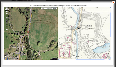
MakkaMappa in action at Braco
The other bit of software I have been looking at is Photosynth another free online program made by Microsoft this time which makes 3D views from ordinary photos. I thought I would have a go with an artefact from the Archaeology Scotland collection. I just put it on a table took 50 photos of it, uploaded them all and the program stuck them all together: http://photosynth.net/view.aspx?cid=293269b8-b0fa-474e-a552-0ab7fdd5f0af
You can now spin round the object and see it from all angles. It’s worth having a play with this program especially try looking at the point cloud data which is very snazzy. We hope to use this on some of our adopt sites to as it’s so simple to use and any image from any camera will do. I can particularly recommend this church and have a look at the aerial view created just from photos taken on the ground!   http://photosynth.net/view.aspx?cid=b2fb01ff-de7d-4383-a4c0-b7a5510f545e

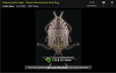
You can use Photosynth for almost anything including insects apparently
You may need to download Silverlight but its only a small program and is useful for all sorts of stuff. Good luck and have fun.